As of April 2026, Istanbul’s public transportation network is one of the largest urban systems in Europe, connecting two continents through an integrated mix of metro, tram, Marmaray, Metrobus, ferries, funiculars, and buses. In practical terms, most districts visitors actually use — including Sultanahmet, Taksim, Galata, Kadıköy, Üsküdar, and both airports — are directly served by this network.
This page is designed to make that system easier to understand. Below, you will find downloadable and high-resolution maps for the metro, tram, Marmaray, Metrobus, and ferry networks, each presented in its own section. If you already know which system you need, simply scroll down to the relevant map and use it directly.
To use almost all of these transportation systems, you will need one essential tool: Istanbulkart. This reloadable transit card works across metros, trams, ferries, Metrobus, and buses, and it is required by almost every visitor from the first day of their trip. If you are visiting for the first time, I have explained everything in detail in my Istanbulkart: Where to Buy and How to Use guide.
This guide reflects more than 20 years of daily experience using Istanbul’s transport system as a licensed Istanbul tour guide, both personally and while leading travelers across the city. In the rest of this guide, each transportation system is explained separately, with its own map and a short practical overview based on real visitor needs.
Public Transportation in Istanbul (2026 Overview)
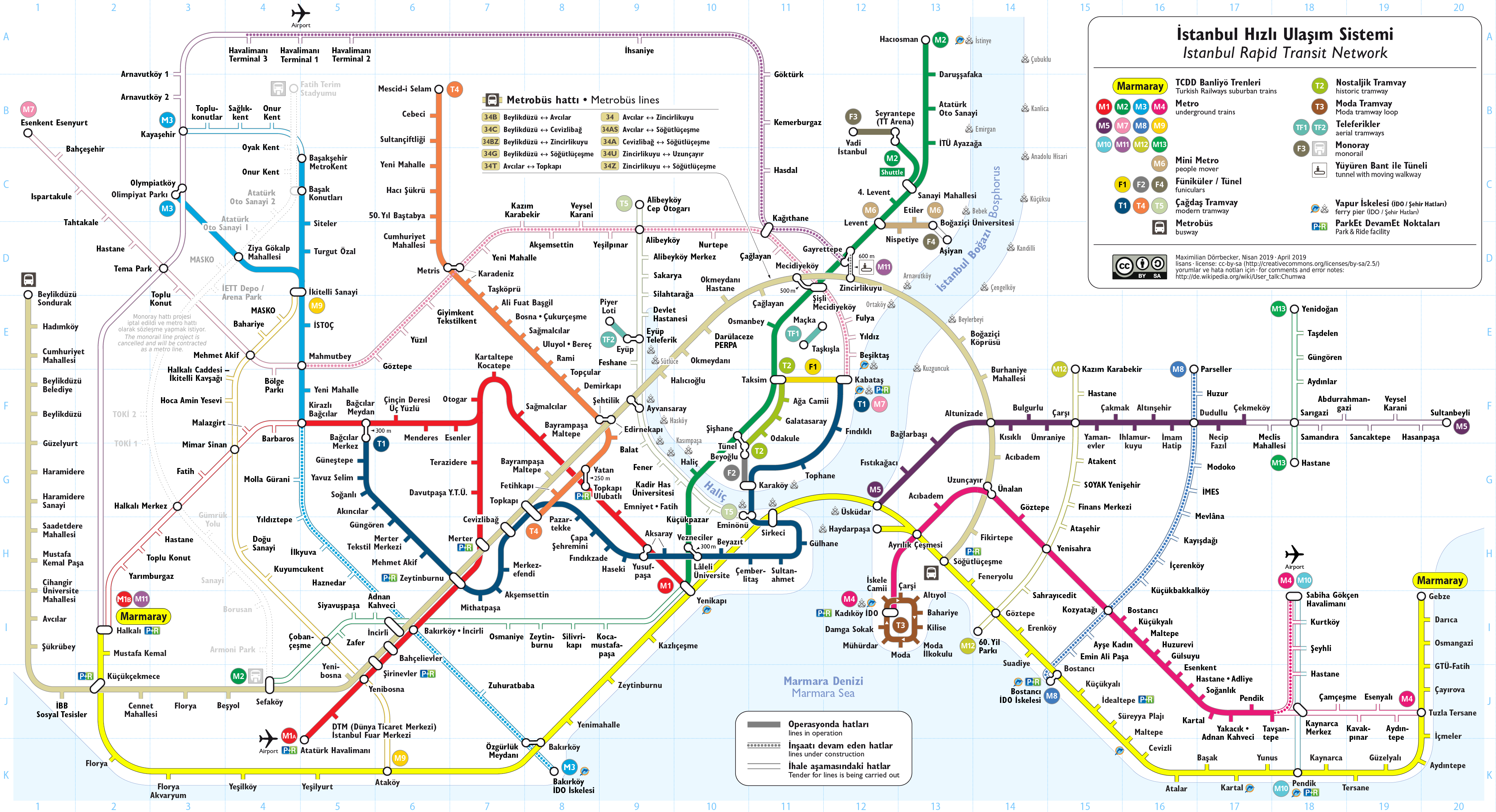
Istanbul’s public transportation system is built around several interconnected networks that operate together as a single, city-wide system. Metro lines, trams, Marmaray trains, Metrobus routes, and city ferries are all designed to complement one another rather than function independently.
The overview map above brings all of these systems together in one place. At first glance, it may look dense — Istanbul is a large city with multiple transport layers — but this map is best used as a big-picture reference. It helps you understand how the city is structured and how different transport modes connect across both the European and Asian sides.
In the sections below, the network is broken down into clear, individual components. Each transport system is explained separately, with dedicated, high-resolution PDF maps, so you can focus only on the lines that are relevant to your trip.
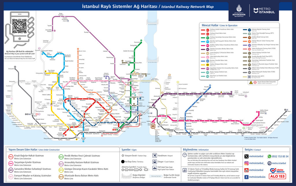
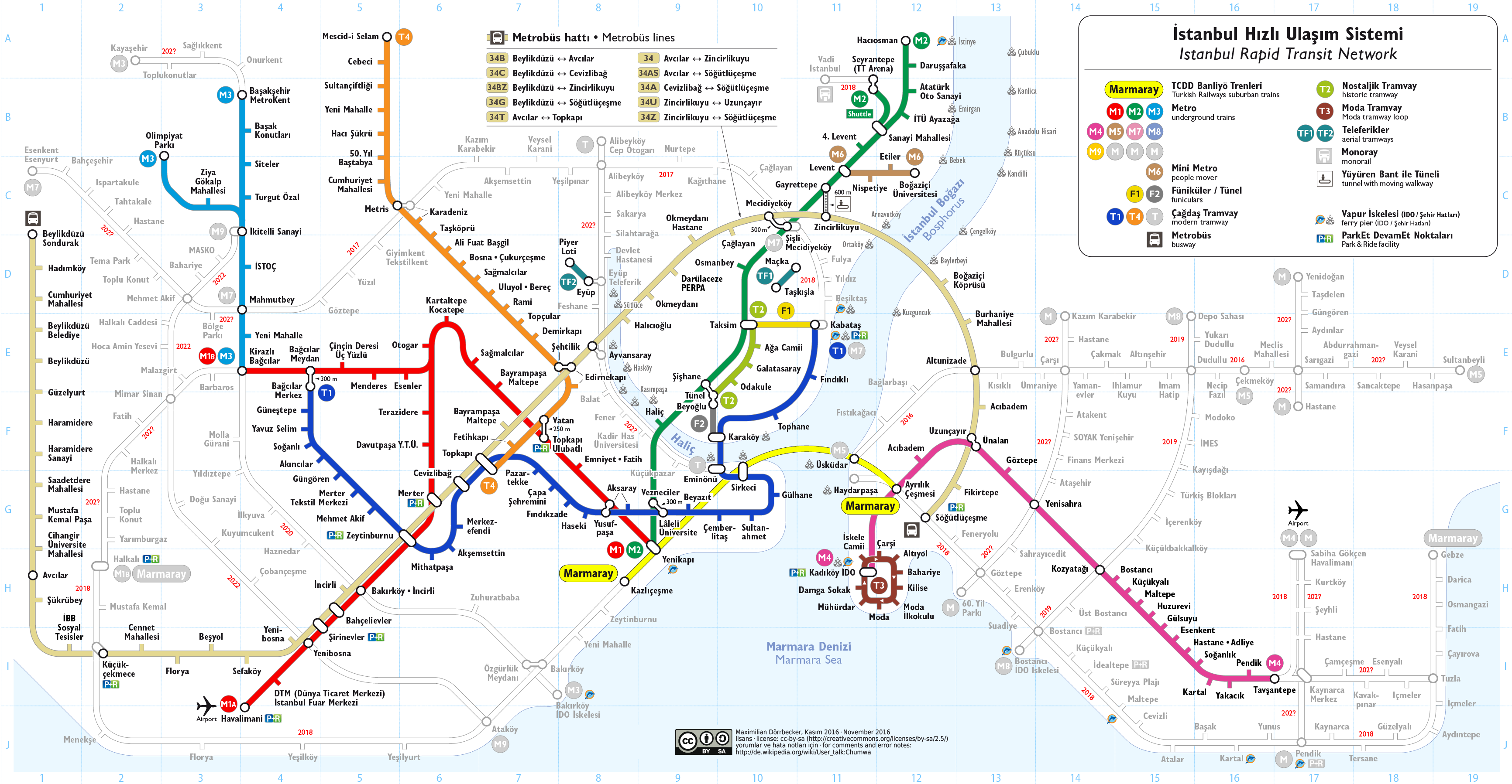
1. Istanbul Metro Map 2026
You can view and download the Istanbul Metro Map in PDF format free of charge using the dark blue button below.
The map is officially prepared by Istanbul Metropolitan Municipality and is suitable for both online viewing and printing.
This high-resolution Istanbul metro map focuses on the main metro lines that are most useful for visitors traveling around the city. Below, you will find a short overview of the metro lines that tourists use most frequently in Istanbul.
Among these, M2, M4, and M11 are the most popular lines, as they provide direct access to key areas such as the historic city center, Taksim, and Istanbul Airport.
M2 Yenikapı – Hacıosman Metro Line
The M2 Yenikapı – Hacıosman Metro Line is the most frequently used metro line in Istanbul. Starting from Yenikapı (Historical Peninsula of Istanbul), one of the city’s main transportation hubs, it provides direct access to major business and lifestyle areas such as Taksim, Levent, and Maslak.
The M2 line is also the most popular metro line among both local residents and foreign visitors, as some of Istanbul’s best-known shopping malls—such as Cevahir, Kanyon, and İstinyePark—are located along this route.
In addition, through its Yenikapı and Vezneciler stations, the M2 line serves the extensive hotel districts of Aksaray, Laleli, and Beyazıt, which are especially popular with families due to their larger hotels and central location. From these areas, the line continues north and provides a direct connection to Gayrettepe, the main transfer point for the Istanbul Airport metro line (M11).
M4 Kadıköy – Sabiha Gökçen Airport Line
The M4 metro line runs on the Asian side of Istanbul, starting from Kadıköy and extending all the way to Sabiha Gökçen Airport. It is the most practical rail connection for travelers heading to or from the airport on the Asian side.
Visitors coming from the European side can reach the M4 line via Marmaray. If you are staying around Beyazıt or Laleli, you can board Marmaray from Yenikapı Station. Those staying in Sultanahmet, Sirkeci, or Eminönü can use Sirkeci Station instead. In both cases, Marmaray crosses to the Asian side and stops at Ayrılık Çeşmesi Station, where a direct and easy transfer to the M4 metro is available.
Once on the M4 line, you can travel not only to Sabiha Gökçen Airport, but also to several of the Asian side’s major shopping centers, including Akasya, Optimum, Palladium, Piazza, and Neomarin. This makes the M4 line useful not just for airport transfers, but also for shopping and everyday travel on the Asian side of the city.
M11 Gayrettepe – Istanbul Airport Line
The M11 Gayrettepe – Istanbul Airport line, completed in 2024, now offers a direct metro connection from the new airport to the city center. You can see that the M11, marked in purple on the above metro map of Istanbul, extends towards the north of the city.
2. Istanbul Tram Map 2026
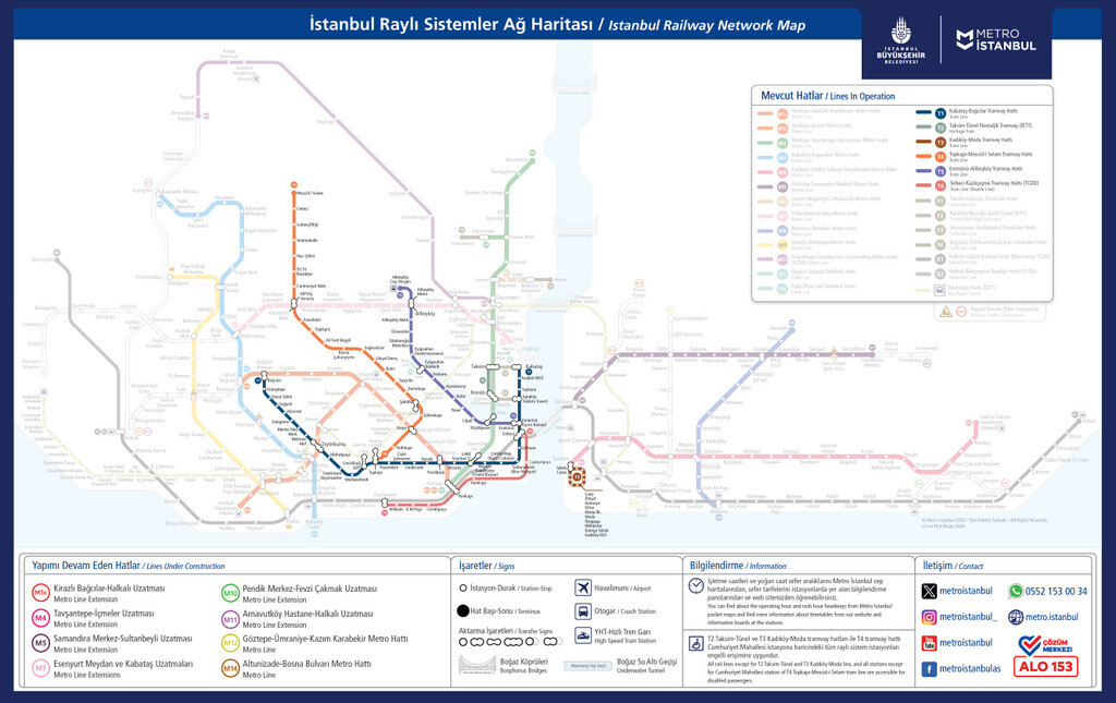
You can view and download the Istanbul Tram Map (2026) in PDF format free of charge using the dark blue button below.
The tram map shown above is officially prepared by Istanbul Metropolitan Municipality and highlights the tram and funicular lines that are most useful for visitors.
Below, you will find brief and practical descriptions of the main lines displayed on this tram map, with a focus on routes commonly used by tourists.
T1 Kabataş – Bağcılar Tram Line
The T1 Kabataş – Bağcılar Tram Line runs from Bağcılar, one of Istanbul’s busiest residential areas, to Kabataş on the Bosphorus waterfront.
While the eastern part of the line mainly serves local commuters, the most important stops for visitors are located closer to Kabataş, passing through key historic areas such as Sultanahmet, Eminönü, and the Grand Bazaar area.
T5 Eminönü – Alibeyköy Tram Line
The T5 Eminönü – Alibeyköy Tram Line is a convenient option for travelers heading from the Old City toward districts like Fener and Balat, Ayvansaray, and Eyüp.
The line starts from a tram stop located very close to the Spice Bazaar, making it easy to combine sightseeing with local transport.
Using this line, you can explore Fener and Balat’s colorful streets, visit Ayvansaray to see the Byzantine city walls, Chora Church, and Tekfur Palace, and continue to Eyüp to reach Pierre Loti Hill.
F1 Taksim – Kabataş Funicular Line
The F1 Taksim – Kabataş Funicular Line is not technically a tram line, but it is shown on the tram map for a practical reason.
The T1 Tram Line, which runs from Sultanahmet to Kabataş, connects directly to Taksim Square via the F1 funicular.
Since Sultanahmet and Taksim Square are the two most important areas for visitors, the easiest way to travel between them is to take the T1 tram to Kabataş and then transfer to the F1 funicular up to Taksim.
The T1 tram is also the most useful transport line for sightseeing in the Old City. Its Sultanahmet stop leaves visitors within a short walk of Hagia Sophia, the Basilica Cistern, and Topkapi Palace, three of Istanbul’s most visited historic monuments. Visitors who plan to see all three on the same day often prefer to reserve a combo ticket covering all three in advance, especially in spring and summer when ticket lines tend to be longer.
3. Istanbul Marmaray Line 2026
On the Istanbul Marmaray Map, the Marmaray route is shown as a yellow line.
You can view and download this map free of charge in PDF format using the dark blue button below. As the map makes clear, Marmaray follows the Marmara coast and passes under the Bosphorus, linking the Asian and European sides through a single rail tunnel.
The Marmaray line starts from Gebze, on the eastern edge of the metropolitan area, and continues westward along the coast before ending at Halkalı. It is a modern rail system built on the city’s historic railway corridor, which is why Marmaray has a relatively large number of stations.
For visitors, the most useful Marmaray stations are located between Ayrılık Çeşmesi (Kadıköy) and Yenikapı, where the line connects with Istanbul’s central transport network.
In the past, ferries were the most reliable way to travel between the Asian and European sides of the city, as crossing the Bosphorus by bus could take an unpredictable amount of time. With the introduction of Metrobus and Marmaray, cross-continental travel in Istanbul has become much faster and more efficient.
Today, Marmaray allows you to travel from Sirkeci (Old City) to Üsküdar in just 4 minutes, or to Kadıköy in about 8 minutes, making it one of the fastest transport options in the city.
Most visitors stay around Sultanahmet or Taksim.
For travelers based in Sultanahmet, the closest Marmaray station is Sirkeci. Those staying in Taksim can take the M2 Metro to Yenikapı, transfer to Marmaray, and continue easily to the Asian Side of Istanbul.
4. Istanbul Metrobus Map 2026
On the Istanbul Metrobus Map, the Metrobus route is highlighted with a light brown line.
You can view and download this map free of charge in PDF format using the dark blue button below. As illustrated above, the Metrobus operates on a dedicated corridor that crosses between the European and Asian sides without being affected by regular road traffic.
The Metrobus line starts from Söğütlüçeşme on the Asian Side, crosses the Bosphorus bridge, and continues westward to Beylikdüzü, one of the outermost districts on the European Side.
While Beylikdüzü itself is not a touristic area, it is home to some of Istanbul’s largest exhibition and fair centers. For this reason, Metrobus can be useful for visitors attending international tourism, food, or book fairs held in this district.
One of the most important advantages of Metrobus is that it provides fast and direct access to the Asian Side from central areas such as Mecidiyeköy and Zincirlikuyu, without the need to pass through Beşiktaş or Taksim.
Many visitors stay in districts like Mecidiyeköy, Şişli, Levent, or Maslak, where there is a wide range of hotels. From these areas, Metrobus offers a much quicker alternative for reaching Kadıköy compared to traditional routes.
The main drawback of Metrobus is crowding during rush hours. It can be very difficult to use between 08:00–10:00 in the morning and 18:00–20:00 in the evening. Outside of these peak hours, however, Metrobus can be a highly efficient and time-saving option for crossing between the two sides of the city.
For travelers arriving at Istanbul Airport (IST) with luggage, Metrobus is usually not the easiest transfer option, since it requires additional connections and can become very crowded at peak hours. A much simpler alternative for travelers with luggage is to pre-book a private airport transfer, especially if you are heading directly to Sultanahmet or Taksim. This can be particularly helpful for late-night arrivals, when public transport connections become more limited.
5. Istanbul Ferry Lines 2026
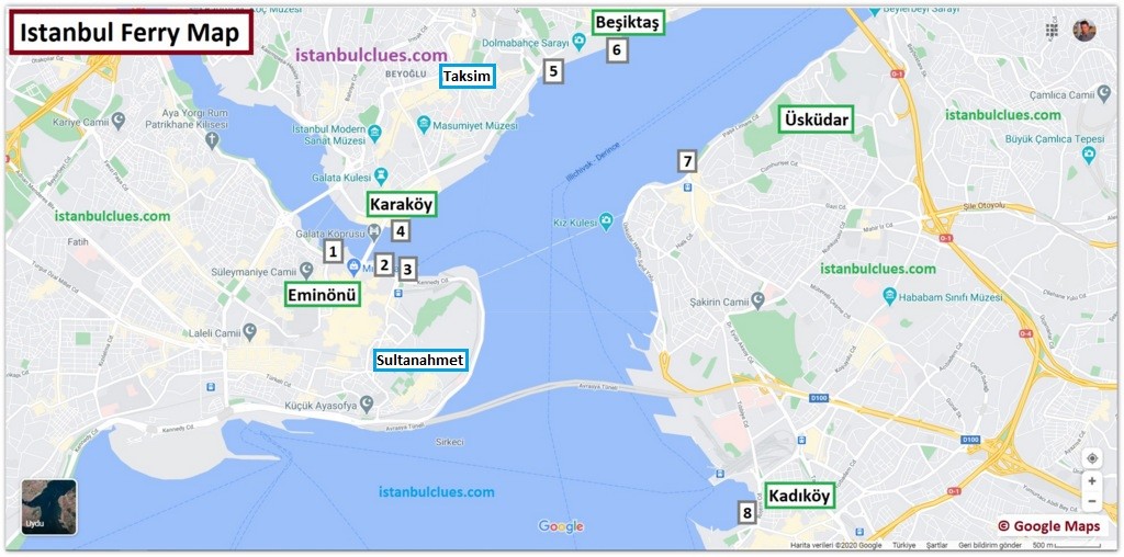
The Istanbul Ferry Map highlights many of the city’s most historic and touristic waterfront areas.
You can view and download this map free of charge in PDF format using the dark blue button below. The map above shows ferry routes connecting key districts along the Golden Horn, the Bosphorus, and both sides of Istanbul.
Since it can be difficult to identify ferry piers only by neighborhood names, the map uses numbered markers. Below is a clear explanation of each numbered ferry route, showing where each ferry departs from and where it goes.
Numbered Ferry Routes on the Map
1) Turyol Bosphorus Cruise
Bosphorus sightseeing cruises operated by Turyol, departing mainly from Eminönü and Karaköy.
2) Şehir Hatları Bosphorus Cruise
Official Bosphorus cruise routes operated by Şehir Hatları, with departures from Eminönü and nearby piers.
3) Eminönü → Kadıköy / Üsküdar
Regular ferry services from Eminönü to the Asian Side, stopping at Kadıköy and Üsküdar.
4) Karaköy → Kadıköy
Direct ferry connection between Karaköy (European Side) and Kadıköy (Asian Side).
5) Dentur Bosphorus Cruise
Bosphorus sightseeing cruises operated by Dentur, departing from central waterfront piers.
6) Beşiktaş → Kadıköy / Üsküdar
Regular ferry services from Beşiktaş to both Kadıköy and Üsküdar on the Asian Side.
7) Üsküdar → Eminönü
Return ferry route from Üsküdar to Eminönü, commonly used by commuters and visitors.
8) Kadıköy → Eminönü
Direct ferry connection from Kadıköy back to Eminönü on the European Side.
It is important to note that ferries departing from Eminönü and Beşiktaş usually serve both Kadıköy and Üsküdar. Since these two districts are located very close to each other, they are grouped together on the map rather than being numbered separately.
While many ferries from Eminönü and Beşiktaş are primarily commuter routes used by locals, some operators also offer Bosphorus cruises designed for sightseeing. These usually follow a longer route along both shorelines, with views of waterfront palaces, historic neighborhoods, and the bridges. If that experience interests you, you can reserve a Bosphorus cruise with a stop on the Asian side, or read my guide to Bosphorus cruise tours in Istanbul for a fuller overview.
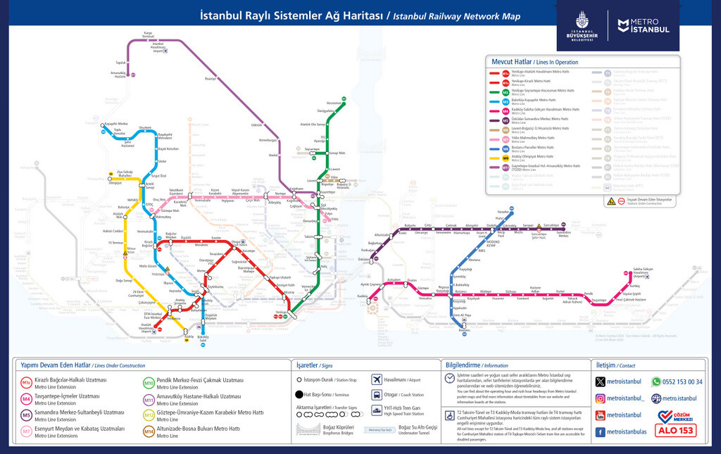
How Istanbul’s Transit Network Has Expanded
Istanbul’s public transport network has grown significantly over the past decade. The map below shows the system as it stood before the most recent extensions. At the time, the M4 metro line ended at Tavşantepe and did not yet continue to Sabiha Gökçen Airport on the Asian side. The M11 line connecting Gayrettepe to Istanbul Airport had not yet opened.

These extensions, together with newer Marmaray connections, have made both international airports and large parts of the Asian side directly reachable through the rail network, without taxi or bus transfers. Looking at the earlier version of the map alongside the current one makes it easier to see how quickly the city’s rail system has developed, and how much of today’s visitor-friendly access is the result of recent additions rather than long-standing infrastructure.
Conclusion
I hope this guide to Istanbul’s metro, tram, Marmaray, Metrobus, and ferry maps has given you the clarity you need to move around the city with confidence. Each of these systems plays a distinct role in Istanbul’s daily life, and understanding how they fit together is one of the most practical skills a visitor can gain.
That said, transportation maps are designed to show routes, not relevance. On most public transport maps, every neighborhood appears the same — reduced to small dots and line intersections — whether it holds world-famous landmarks or places of little interest to visitors. Knowing where a line goes is useful; knowing where it’s worth getting off is what truly shapes a good trip.
If you’d like to see Istanbul through a more visitor-focused lens, I recommend taking a look at my Istanbul Tourist Attraction Maps guide. That article highlights historic districts, major landmarks, and sightseeing zones, helping you connect transportation routes with the places that actually define the city. Used together, these guides allow you to plan your days not just efficiently, but meaningfully — turning movement across Istanbul into a well-paced and rewarding journey.

Hi Serhat,
Thank you for your information on this site! I haven’t been to Istanbul in many years. I have an Istanbulkart that is at least 10 years old. Would it still be be working you think?
Also, where do you check in with your cart into a tram or metro? Do you also have to check out or only check in? (Where I live you have to check in and out when traveling on public transport).
Hi Fabienne, I have Istanbulkarts that I have been using for many years. If there is no damage to the magnetic section, I think you can use it even after 10 years.
You only scan the card when you get on. If you only cross from the European side to the Asian side, you also need to scan it to get a refund when you exit.
Incredible helpful detailed source of information! Even after having perused a myriad of internet sites, blogs, travel guides, and books by Turkish authors, I still find new information, which is beautifully organized by the way, on this site. This is definitely the best source of information! Thank you very much!
Hi Carine, it’s great to get such positive feedback about the articles on the site. As someone born and raised in Istanbul, I share everything I know about the city with people through this site and it’s great to see that it’s working!
Hi,
Do you by chance know if T6 (U3) Yenikapi Station is at the same site as Marmaray Yenikapi Station.
Appreciate your good work.
Dear Forst Hussin, thank you for your kind words about my work. Yes, Yenikapi Station is the terminal station where metro, tram and Marmaray lines meet.
Hello. You should update the map. There are four more new lines recently opened. Thanks 🙏
Hello, thank you for the feedback. I will update the maps in a few days.
EDIT: I added the latest version of the Istanbul Metro Map as of March 28, 2024, as promised. Thanks again for the heads up.
Hi Serhat,
You are our salvation in Istanbul.
Hi Silviya, thank you for your feedback. It’s a great feeling that what I write is useful to people. I wish you a nice trip in Istanbul.
Hello, I really like the work you have done and thanks so much. I was wondering if you could add to the maps for the trams and metro, which stops are wheelchair accessible and have accessible restroom. Thanks for all you do!
Hi Pedro, as far as I know, all metro stations have modern and spacious elevators for wheelchair users. I don’t think there will be a problem in this regard in Metro and Marmaray.
However, I cannot say that all stops on the T1 tram line and Metrobus line (ie on public transportation vehicles serving above ground) are wheelchair friendly.
I don’t have a map on this subject. However, you can check whether such information is available on the official website of the Istanbul Metropolitan Municipality.
Thank you for your highly informative website. I will be visiting Istanbul in the first week of Febraury 2023, what is the status of the ticket queues at Topkapi Museum?
Also I would like to know if I could reach Eyup Sultan by ferry from Eminonu (public ferry)? Also is there a ferry port to the Ortakoy Cami area and also to the Rumeli Hisari Fortress. (Direct public ferries or nearest ferry docks to these areas).
Also other attractions in the city for Muslim a tourist (burial sites,historical mosques etc) Looking forward to your response. Thanking you once again. Salaams.
Hi Mobin, thanks for your feedback about the site. The answers to most of these questions can be found in the articles on the site.
If you search for words such as Topkapi Palace, Mosques in Istanbul and Ortakoy Mosque from the search box on the right, you can find related articles.
I do not know the details of the ferry services from Eminonu. You can visit the Sehir Hatlari site from here. This site has charts about public ferries.
Merhaba Serhat bey,
Gerçekten çok başarılı anlatım ben çok beğendim. Duydum ki, Sabiha Gökçen Havalimanı metrosu açılmış.
Kosova’dan selamlar…
Merhaba Orhan Bey,
Öncelikle nazik yorumunuz için çok teşekkür ederim. Evet M4 metrosu artık Kadıköy’den Sabiha Gökçen’e kadar uzanıyor. Bu konuda gerekli güncellemeyi yakında yapacağım.
Selamlar ve Saygılar,
Serhat
Hello! Thanks for your blog! It is really useful.. I will go with my wife to Istanbul this month and I need to know some things. I will write some issues and if it is wrong please correct me.
– It is enough to buy only one Istanbul card for both of us
– the price for a card is 50 tl (25 the plastic and 25 for travel )
– I can charge the card with another amount than those 25 tl when I buy the card
– I can make only 5 transfers in 2 hours (for one traveler or for both?)
– the fist trip is about 7 tl for one of us or for both?
– when I touch the machine with the card in the first station for two times it means that I make a first trip and a transfer or two first trips? (I mean how much amount takes the machine in this case?)
– which are the prices for the rest of transfers in those two hours?
– how many groups of two hours I can use this card. There is a limit or I can use it till the amount is off?
– the card is valid for Marmaray train, too?
Thank you again!
Alexandru
Hi Alexandru, frankly I was stressed when I saw the length of the question list. But fortunately, this blog already has all the information a first time tourist in Istanbul would need.
I think you better read this article about Istanbulkart. You can find the answers to most of these questions there.
PS: If you can’t find the answers to some of your questions in the articles, it means I don’t know about that subject.
Kind regards,
Serhat
Serhat, thank you very much for this amazing article, it is specially very beneficial for solo female travelers like me. I am going to visit Turkey in May, I am more interested in religious sites and want to ask a query, if you please reply I would be really grateful, I want to visit Abu Ayup tomb and Chora church(which i believe is now a mosque), are these two places open for female travelers to visit?
Moreover, could you please suggest some religious sites that I should visit? I have already visited all the usual places like Aya Sofia, Blue Mosque, Topkapi, Sulemaniya Mosque, etc.
Hi Moon, first of all thank you for your kind feedback on the blog. Eyup Sultan Mosque and its tomb are open to women. However, Kariye Mosque (former Chora Church) is unfortunately closed to visitors due to restoration.
Chora was originally a museum for many years under the name of Kariye Museum. It was turned back into a mosque in 2020. However, it is not known how it will continue as a mosque, as its walls are covered with Byzantine mosaics.
There are many mosques in Istanbul that are of great spiritual importance. For example, in the best mosques of Istanbul article, I shared brief information about the history and architecture of 25 mosques.
Thank you for your reply, Serhat!
I read the article that you mentioned, it is yet another amazing piece of writing. Have left a comment there. Please reply 🙂
You are welcome!
Hi Serhat, Your site is very useful. I heard the Metro to IST is going to be open soon. Can you please update on the progress of the Metro lines to IST and Sabiha Gokcen?
Hello Muhammad I will update the article when the metro lines to New Istanbul Airport and Sabiha Gokcen become operational. News about subway constructions can be misleading. Delays are common in projects like this.
Very useful. Thank you (-:
Hi Jan, thank you for the feedback. 🙂
This is brilliant thank you so much
Hi Anisa, thank you for your kind review.
MUHAMMAD ZAKIR Excellent article 👌
I have been to Istanbul last year for 10 days. Fou your information very useful. Keep it up. Stay blessed, take care!
Love from Karachi, Pakistan.
Hello Muhammad, Thank you for your kind words. Feedbacks are really useful for keep it going. Love from Turkey.
SERHAT
You are a real mensch. This article is very helpful, detailed, and informative. Hat off to you, sir.
Dear Yousef, thank you for the great feedback. I am happy to see that it’s been useful to you. Cheers!