Istanbul metro map has introduced many new lines in the last few years. In this article, you can find PDF links of the Istanbul public transportation map and brief information about its main lines.
We will mainly focus on the lines surrounding Taksim and Sultanahmet (Old City). While giving tips on how to use public transportation in Istanbul, we will look at the city through the eyes of a tourist who wants to see historical places and shop.
1. Istanbul Metro Map 2024
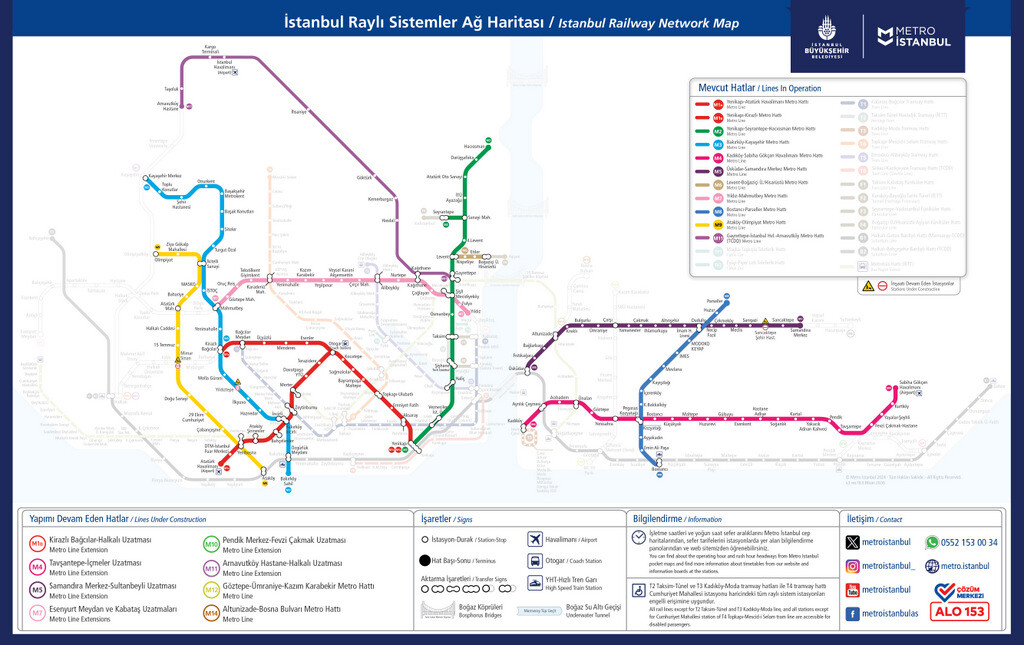
You can download the metro map of Istanbul as a printable PDF file from this link. This map has been prepared by Istanbul Metropolitan Municipality and is free to download.
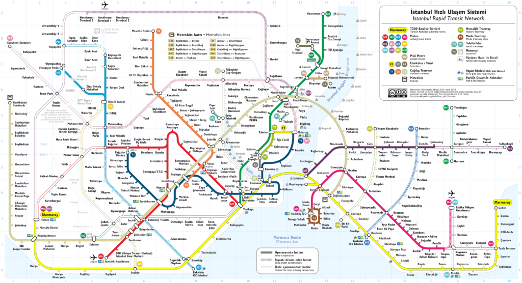
It should be noted that the map above contains only subway lines. You can also download the public transportation map of Istanbul including all the rail systems as a printable PDF file here (map at the bottom of the article).
In the following lines, you can find a brief description of the lines that will be most useful to tourists. The most popular metro lines in Istanbul are M2 and M4 and M11 respectively.
M2 Yenikapı – Hacıosman Metro Line
M2 Yenikapı – Hacıosman metro line is the most used metro line in Istanbul. This metro line starting from Yenikapi, the transport hub of the Old City, provides access to the city’s most important business centers such as Taksim, Levent and Maslak.
M2 metro line is the most used metro line by local or foreign tourists visiting the city. Because the best shopping malls in Istanbul such as Cevahir, Kanyon and IstinyePark are located on this line.
This line also connects hotels in the Historical Peninsula (Sultanahmet and its surroundings) to Gayrettepe, the first stop of the new airport metro (M11).
M4 Kadıköy – Sabiha Gokcen Airport Line
M4 Kadıköy – Sabiha Gokcen Airport Line connects the touristic districts to Sabiha Gokcen (Istanbul’s second airport), located in a remote corner of the Asian Side. Those on the European Side need to use Marmaray to reach Kadikoy first.
Those who stay around Beyazit and Laleli can get on Marmaray from Yenikapi Station. On the other hand, those who stay in places such as Sultanahmet, Sirkeci and Eminonu can also go to the Asian Side by Marmaray from Sirkeci Station.
Leaving the Old City, Marmaray comes to a station called “Ayrilik Cesmesi” on the Asian Side. You can transfer to M4 here. You can go to Sabiha Gokcen Airport by M4 metro, as well as Akasya, Optimum, Palladium, Piazza and Neomarin, which are the most popular shopping malls on the Asian Side.
M11 Gayrettepe – Istanbul Airport Line
M11 Gayrettepe – Istanbul Airport metro line was completed in 2024. It is now possible to come from Istanbul’s new airport to the city center by metro. You can see that the M11, marked in purple on the above metro map of Istanbul, extends towards the north of the city.
2. Istanbul Tram Map 2024
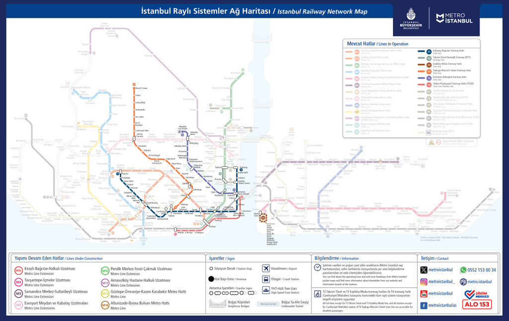
You can download the tram map of Istanbul as a printable PDF file from this link. This map has been prepared by Istanbul Metropolitan Municipality and is free to download. The following lines have detailed descriptions of the lines you will see on this tram map.
T1 Kabataş – Bağcılar Tram Line
T1 Kabataş – Bağcılar tram line starts from Bagcilar, one of the most crowded suburbs of the city. However, the most important stops for tourists are seen as the tram approaches Kabatas direction.
T1 is the most important tram line for tourists visiting Istanbul. You can review the stops of this vehicle, which covers the touristic places of Istanbul, by clicking this article.
T5 Eminönü – Alibeykoy Tram Line
T5 Eminönü – Alibeykoy Tram Line is a practical means of transportation, especially from the Old City to districts such as Fener and Balat, Ayvansaray, Eyup, and starts from a tram station very close to Spice Bazaar.
You can go to Fener and Balat and see the colorful houses and stairs of Istanbul, go to Ayvansaray and see the Byzantine city walls, Chora Church and Tekfur Palace, and go to Eyup and see Pierre Loti Hill.
F1 Taksim – Kabatas Funicular Line
F1 Taksim – Kabatas funicular line is not actually in the tram category. However, there is an important reason for placing it under this title. The T1 Tram Line, departing from Sultanahmet and arriving at Kabatas, connects to Taksim Square through the F1 transfer.
The two most important places for tourists visiting the city are Sultanahmet and Taksim Square. For this reason, we can say that the easiest way to go from Sultanahmet to Taksim is to reach Kabatas first with the T1 and then to Taksim Square with F1.
3. Istanbul Marmaray Line 2024
You can see Marmaray’s route from the yellow line on the Istanbul Marmaray Map. Starting from Gebze at the eastern end of Istanbul, the Marmaray line continues along the Marmara coast of the city and ends at Halkali, the western end.
Marmaray is a means of transportation blended with the old train lines of the city. For this reason, it has dozens of stops. Since we take the touristic centers as reference in the Istanbul metro map article, we will only talk about the stations of Marmaray between the Ayrilik Cesmesi (Kadikoy) and Yenikapi.
In the past, ferry was the most guaranteed way to travel between the Asian and European sides of Istanbul. Because when you used the bus, you could never be sure how long it would take to cross the bridge.
With Metrobus and Marmaray added to public transportation in Istanbul, it became easier to travel between two sides. For example, with Marmaray, you can go from Sirkeci (Old City) to Uskudar in just 4 minutes or to Kadikoy in 8 minutes.
Tourists who visit the city mainly stay in Taksim and Sultanahmet. For someone staying around Sultanahmet, the closest Marmaray stop is in Sirkeci. Those coming from Taksim can come to Yenikapi by M2 Metro and connect to Marmaray and then cross to the Asian Side.
You can download the Marmaray map of Istanbul as a printable PDF file from this link.
4. Istanbul Metrobus Map 2024
You can see the route of Metrobus from the light brown line on the Istanbul Metrobus Map. The Metrobus line, starting from Sogutlucesme on the Asian Side, crosses the bridge and continues to Beylikduzu, one of the farthest points of the European Side.
There is no historical place in Beylikduzu that tourists visiting the city can see. However, as Istanbul’s biggest exhibition centers are there, Metrobus may be useful for some tourists. Beylikduzu sometimes hosts international tourism, food and book fairs.
In addition, the most important feature of Metrobus will be that it provides fast access to the Asian Side from places such as Mecidiyekoy and Zincirlikuyu.
There are many hotels in districts of Istanbul such as Mecidiyekoy, Sisli, Levent and Maslak. Those who stay there normally need to reach Besiktas or Taksim first to get to Asian Side. However, Metrobus bypasses this old route and quickly takes passengers to Kadikoy.
The biggest problem with metrobus is the crowd at rush hours. It is quite difficult to use Metrobus between 8 and 10 in the morning and between 6 and 8 in the evening. However, it can be very beneficial to use Metrobus outside of these busy hours.
You can download the metrobus map of Istanbul as a printable PDF file from here.
5. Istanbul Ferry Lines 2024
Istanbul Ferry Map contains the most attractive historical and touristic spots in the city. The ferry, which provides transportation between districts such as Eminonu, Karakoy, Besiktas, Uskudar and Kadikoy, promises a nostalgic journey to its passengers.
The ferry piers on the map are 1) Turyol Bosphorus Cruise, 2) Sehir Hatlari Bosphorus Cruise, 3) Eminonu-Kadikoy (and Uskudar), 4) Karakoy-Kadikoy, 5) Dentur Bosphorus Cruise, 6) Besiktas-Kadikoy (and Uskudar), 7) Uskudar-Eminonu, 8) Kadikoy-Eminonu.
It should also be noted that there are ferries departing from Eminonu and Besiktas piers to both Kadikoy and Uskudar (districts on the Asian Side). Since they are side by side, I did not see the need to number them separately.
You can download the ferry map of Istanbul as a printable PDF format from this link.
Conclusion
I hope this article, in which I present metro, tram and ferry map of Istanbul, will be useful to you. However useful these maps are, they do not make a comparison between the districts of Istanbul. All neighborhoods, interesting or not, are marked as a small dot.
If you want to get a better understanding of the tourist attractions in the city, you can also review my article titled Istanbul Tourist Attraction Maps. The information there will allow you to make a plan about best places to visit in Istanbul.
As a footnote, we examined transportation vehicles by dividing them into parts such as metro, tram and funicular. The dense map above shows all the rail systems of Istanbul together and you can access the PDF version from this link.
Written by Serhat Engul


SERHAT
You are a real mensch. This article is very helpful, detailed, and informative. Hat off to you, sir.
Dear Yousef, thank you for the great feedback. I am happy to see that it’s been useful to you. Cheers!
MUHAMMAD ZAKIR Excellent article 👌
I have been to Istanbul last year for 10 days. Fou your information very useful. Keep it up. Stay blessed, take care!
Love from Karachi, Pakistan.
Hello Muhammad, Thank you for your kind words. Feedbacks are really useful for keep it going. Love from Turkey.
This is brilliant thank you so much
Hi Anisa, thank you for your kind review.
Very useful. Thank you (-:
Hi Jan, thank you for the feedback. 🙂
Hi Serhat, Your site is very useful. I heard the Metro to IST is going to be open soon. Can you please update on the progress of the Metro lines to IST and Sabiha Gokcen?
Hello Muhammad I will update the article when the metro lines to New Istanbul Airport and Sabiha Gokcen become operational. News about subway constructions can be misleading. Delays are common in projects like this.
Serhat, thank you very much for this amazing article, it is specially very beneficial for solo female travelers like me. I am going to visit Turkey in May, I am more interested in religious sites and want to ask a query, if you please reply I would be really grateful, I want to visit Abu Ayup tomb and Chora church(which i believe is now a mosque), are these two places open for female travelers to visit?
Moreover, could you please suggest some religious sites that I should visit? I have already visited all the usual places like Aya Sofia, Blue Mosque, Topkapi, Sulemaniya Mosque, etc.
Hi Moon, first of all thank you for your kind feedback on the blog. Eyup Sultan Mosque and its tomb are open to women. However, Kariye Mosque (former Chora Church) is unfortunately closed to visitors due to restoration.
Chora was originally a museum for many years under the name of Kariye Museum. It was turned back into a mosque in 2020. However, it is not known how it will continue as a mosque, as its walls are covered with Byzantine mosaics.
There are many mosques in Istanbul that are of great spiritual importance. For example, in the best mosques of Istanbul article, I shared brief information about the history and architecture of 25 mosques.
Thank you for your reply, Serhat!
I read the article that you mentioned, it is yet another amazing piece of writing. Have left a comment there. Please reply 🙂
You are welcome!
Hello! Thanks for your blog! It is really useful.. I will go with my wife to Istanbul this month and I need to know some things. I will write some issues and if it is wrong please correct me.
– It is enough to buy only one Istanbul card for both of us
– the price for a card is 50 tl (25 the plastic and 25 for travel )
– I can charge the card with another amount than those 25 tl when I buy the card
– I can make only 5 transfers in 2 hours (for one traveler or for both?)
– the fist trip is about 7 tl for one of us or for both?
– when I touch the machine with the card in the first station for two times it means that I make a first trip and a transfer or two first trips? (I mean how much amount takes the machine in this case?)
– which are the prices for the rest of transfers in those two hours?
– how many groups of two hours I can use this card. There is a limit or I can use it till the amount is off?
– the card is valid for Marmaray train, too?
Thank you again!
Alexandru
Hi Alexandru, frankly I was stressed when I saw the length of the question list. But fortunately, this blog already has all the information a first time tourist in Istanbul would need.
I think you better read this article about Istanbulkart. You can find the answers to most of these questions there.
PS: If you can’t find the answers to some of your questions in the articles, it means I don’t know about that subject.
Kind regards,
Serhat
Merhaba Serhat bey,
Gerçekten çok başarılı anlatım ben çok beğendim. Duydum ki, Sabiha Gökçen Havalimanı metrosu açılmış.
Kosova’dan selamlar…
Merhaba Orhan Bey,
Öncelikle nazik yorumunuz için çok teşekkür ederim. Evet M4 metrosu artık Kadıköy’den Sabiha Gökçen’e kadar uzanıyor. Bu konuda gerekli güncellemeyi yakında yapacağım.
Selamlar ve Saygılar,
Serhat
Thank you for your highly informative website. I will be visiting Istanbul in the first week of Febraury 2023, what is the status of the ticket queues at Topkapi Museum?
Also I would like to know if I could reach Eyup Sultan by ferry from Eminonu (public ferry)? Also is there a ferry port to the Ortakoy Cami area and also to the Rumeli Hisari Fortress. (Direct public ferries or nearest ferry docks to these areas).
Also other attractions in the city for Muslim a tourist (burial sites,historical mosques etc) Looking forward to your response. Thanking you once again. Salaams.
Hi Mobin, thanks for your feedback about the site. The answers to most of these questions can be found in the articles on the site.
If you search for words such as Topkapi Palace, Mosques in Istanbul and Ortakoy Mosque from the search box on the right, you can find related articles.
I do not know the details of the ferry services from Eminonu. You can visit the Sehir Hatlari site from here. This site has charts about public ferries.
Hello, I really like the work you have done and thanks so much. I was wondering if you could add to the maps for the trams and metro, which stops are wheelchair accessible and have accessible restroom. Thanks for all you do!
Hi Pedro, as far as I know, all metro stations have modern and spacious elevators for wheelchair users. I don’t think there will be a problem in this regard in Metro and Marmaray.
However, I cannot say that all stops on the T1 tram line and Metrobus line (ie on public transportation vehicles serving above ground) are wheelchair friendly.
I don’t have a map on this subject. However, you can check whether such information is available on the official website of the Istanbul Metropolitan Municipality.
Hi Serhat,
You are our salvation in Istanbul.
Hi Silviya, thank you for your feedback. It’s a great feeling that what I write is useful to people. I wish you a nice trip in Istanbul.
Hello. You should update the map. There are four more new lines recently opened. Thanks 🙏
Hello, thank you for the feedback. I will update the maps in a few days.
EDIT: I added the latest version of the Istanbul Metro Map as of March 28, 2024, as promised. Thanks again for the heads up.
Hi,
Do you by chance know if T6 (U3) Yenikapi Station is at the same site as Marmaray Yenikapi Station.
Appreciate your good work.
Dear Forst Hussin, thank you for your kind words about my work. Yes, Yenikapi Station is the terminal station where metro, tram and Marmaray lines meet.